


Basics
- Location:
- The Skyway runs through western North Carolina through the Nantahala and Cherokee National Forests.
- Length:
- 42.95 miles (69 km)
- Time:
- 2 hours to drive the Byway
- Fees:
- Fees may be charged at attractions along the way.
Description
I think that I shall never see a poem lovely as a tree. The poet Joyce Kilmer, honored by the nearby Joyce Kilmer Memorial Forest in North Carolina, penned this famous line many years ago. Experience first-hand the towering trees this poem pays tribute to by traveling the Cherohala Skyway in North Carolina and Tennessee, and you will agree that nothing could be lovelier.
Visit in the fall when vibrant vermillion, golden, and orange leaves drape the trees surrounding the Skyway. Or plan a leisurely summer road trip, leaving plenty of time for picnics, hikes, fishing or many of the other activities available on the Cherohala Skyway. With hundreds of miles of hiking trails traversing the national forests, you're bound to find a favorite. Botany lovers will want to whip out their sketchbooks to capture in ink some of the 2,000 native plant species that thrive around the Cherohala Skyway. Catch your breath by pausing to admire the wildflowers sprinkled throughout the landscape in the spring or make camp at one of the many campgrounds and spend several days exploring the backwoods. You can find out why Nantahala National Forest means "land of the noonday sun" or the Cherokee National Forest is sometimes seen as "Land of the Waterfalls."
The Skyway offers sparkling waters to explore as well. Bald River Falls is beautiful in summer, but captivating in winter when covered in ice. For those who love to travel on the water, follow the Tellico River with paddle in hand and bask in the sunlight and beauty of the surrounding forests. The river parallels part of the Skyway, delighting canoeists and kayakers from all over. Take a boat ride on one of America's largest underground lakes, the Lost Sea. The striking azure waters of Lake Tellico await you for fishing, boating, or swimming. Or just camp along the shore, making it a full day on the beaches of one of Tennessee's Lakes.
From Cherokee to British history, you can tread in the footsteps of the past while surrounded by the natural beauty of the Skyway.
Points of Interest
Points of Interest Along The Way
Bald River Falls (NC)
Although they are not directly on the Cherohala Skyway, the BaldRiver Falls are a gorgeous spot with plenty of scenic outdoor attractions. Visitors can view the falls from the road, or park andwalk to enjoy them. Beautiful in the summer, the falls are entrancing in the winter when they are covered in ice.
Directions
South of the Skyway along the Tellico River.
Brushy Ridge (NC)
Enjoy a snack or a picnic lunch at Brushy Ridge, which overlooks Sassafras Ridge as well as several other ridges that run south to the Tellico River.
Cherokee National Forest (NC)
With more than 145,380 acres, the Cherokee National Forest has a rugged beauty all its own. But it is mainly known for its spectacular white water, and might be thought of as the "Land of Waterfalls." The Ocoee River is very well-known and has been the site of national whitewater championships. One of the largest waterfalls in the region, Bald River Falls, can be viewed without leaving your car. Kayakers and swimmers can often be seen challenging mother nature at Baby Falls.
Directions
The Tennessee section of the Cherohala Skyway travels through the forest.
Fort Loudoun State Park (NC)
This reconstructed British fort is located at an island on Lake Tellico. Just north of the Cherohala Byway, Fort Loudoun may be worth a visit for the history lover.
The Fort was originally used from 1756-1760. A visitor's center is now located on the island and offers a history and explanation of the French and Indian War.
Since the fort is located on a lake island, it also offers a lovely beach, walking trails, picnic areas, and a fishing pier. Visitors are welcomed to a taste of history in a beautiful setting.
Directions
North of the byway on state roadway 360.
Joyce Kilmer Memorial Forest (NC)
Joyce Kilmer, the poet who is best remembered for his poem "Trees," (I think that I shall never see a poem lovely as a tree . . .) and who was killed in action in France during WWI, has a living memorial in his memory. The Joyce Kilmer Memorial Forest is an impressive 3,800 acre remnant of virgin wilderness, now the largest stand of old growth trees in the eastern United States. The dedication took place on July 30, 1935, on the eighteenth anniversary of the poet's death. At the dedication, a letter from President Franklin D. Roosevelt was read.
In this most beautiful, unmarred and natural setting, that was the unchartered hunting ground of the Cherokee Indians, virgin trees grow more than 100 feet tall and some 20 feet around the base. In addition to these trees, there is an outstanding variety of shrubs, vines, ferns, mosses, lichen, liverworts and herbaceous plants. In Spring, wildflowers take advantage of the sunlight which will not be available after the hardwood trees are covered with shade producing leaves. The Memorial Forest, comprised of huge poplars, giant red oaks and magnificent hemlocks, as well as many other varieties of trees, is maintained in its primitive and natural state. No plants living or dead may be cut or removed.
Directions
The Memorial Forest may be reached by following US 129 North of Robbinsville and taking 143 West, also known as Massey Branch Road. Follow the signs.
Junaluska Memorial and Museum (NC)
As a representative of the Cherokee culture, Junaluska was a hero and a warrior. In 1814 he was said to have saved Andrew Jackson's life in the Battle of Horseshoe Bend from the Creek Indians. Ironically, Jackson was the same president who demanded the Cherokee removal to Oklahoma. The beginning of the Cherokee Trail of Tears is here as well as Junaluska's grave. Junaluska tried every appeal to keep his people in their homeland, but to no avail. Junaluska returned to the land many years later. He was buried in Robbinsville where the Memorial now stands. A museum dedicated to the Cherokee culture can also be found in this area.It includes artifacts, artwork, and tools of the Cherokee people.
Directions
In Robbinsville
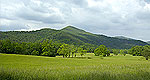
Lake View (NC)
From Lake View, a distant view of Tellico Lake can be seen; this is a perfect place to capture a picture of the area.
Lost Sea (NC)
Deep inside a mountain near Sweetwater in East Tennessee is a remarkable body of water known as the Lost Sea. Listed by the Guinness Book of World Records as the largest underground lake, the Lost Sea is part of an extensive and historic cave system called Craighead Caverns.
Directions
The Lost Sea is located off Interstate 75 on Tennessee Highway 68 in Sweetwater, TN.
Nantahala National Forest (NC)
This beautiful forest lies in the mountains and valleys of western North Carolina between Waynesville and Murphy. Elevations in the Nantahala National Forest range from a low of 1,200 feet along the Tusquitee River below the Appalachian Dam in Cherokee County to a high of 5,800 feet at Lone Bald in Jackson County. The Cheoah, Highlands, Tusquitee, and Wayah Ranger Districts form the Nantahala National Forest. Their headquarters are in several mountain communities, situated along the western recesses of the Appalachian Mountains. The Wayah District is located in Franklin,North Carolina.
With the exception of Highlands, the other three districts have taken their names from the Cherokee Indian language. Cheoah is the Cherokee word for otter, Tusquitee is Cherokee forwhere the water dogs laughed, and Wayah is Cherokee forwolf. Even the term Nantahala is a Cherokee Indian word meaning land of the noonday sun, a fitting name for thedeep valleys and gorges where the sun only penetrates to the valley floor when directly overhead at noon. With over half a million acres, the Nantahala is the largest of the four national forests in North Carolina.
Directions
The North Carolina section of the Cherohala Skyway traverses the Nantahala National Forest over its entire length.
Robbinsville (NC)
Located near the easternmost end of the Byway, Robbinsville is the gateway to areas like the Joyce Kilmer Memorial Forest.
Directions
Off of NC 143 and US 129.
Details
Location:
Length:
Time:
Trip will take longer than 2 - 3 hours if stops are made.

